| Coming From: |
Directions to the Store: |
| Guelph |
- Take 24 (Eramosa Road) East out of Guelph through Erin to Highway 10 in Caledon.
- Turn left onto 10 taking it North to Orangeville.
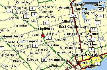
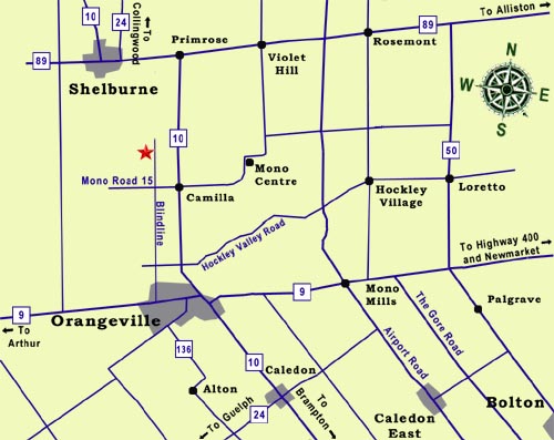
- Continue past Orangeville on Highway 10 about 6 miles (10 km) until you see a flashing yellow over the highway at Camilla at the 15th Sideroad.
- Turn left (west) at the flashing light onto Mono Road 15 and go 1 mile (2 km) until you come to a stop sign at Blind Line.
- Turn right (North) on Blind Line and follow it for 1 mile (2 km).
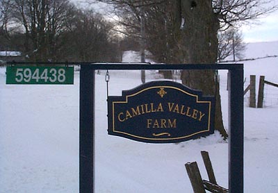
- As you come down the hill look for a blue Camilla Valley Farm sign on the left and turn in the driveway just past it.
|
Toronto
(East of Highway 427) |
- Drive North on the 427 Highway until it ends at Zenway Blvd.
- Turn left (west) on Zenway Blvd and drive about 1 1/4 miles (2 km) to the Gore Road (Zenway becomes Fogal Road).
- Turn right on the Gore road (North) and follow it for about 20 miles (30 km) until it ends at Highway 9.
- Turn left (West) on Highway 9 and go about 10 miles (15 km) until you come to Highway 10 just east of Orangeville.
- Turn right (North) on Highway 10 and follow it for about 6 miles (10 km) until you see a flashing yellow over the highway at Camilla at the 15th Sideroad.
- Turn left (west) at the flashing light onto Mono Road 15 and go 1 mile (2 km) until you come to a stop sign at Blind Line.
- Turn right (North) on Blind Line and follow it for 1 mile (2 km).
- As you come down the hill look for a blue Camilla Valley Farm sign on the left and turn in the driveway just past it.
|
Toronto
(West of Highway 427) |
- To bypass downtown Brampton, take Highway 410 North until it merges with Hurontario (Highway 10 North).
- Keep going north on Highway 10 and drive 20 miles (35 km) to Orangeville.
- Continue past Orangeville on Highway 10 about 6 miles (10 km) until you see a flashing yellow over the highway at Camilla at the 15th Sideroad.
- Turn left (west) at the flashing light onto Mono Road 15 and go 1 mile (2 km) until you come to a stop sign at Blind Line.
- Turn right (North) on Blind Line and follow it for 1 mile (2 km).
- As you come down the hill look for a blue Camilla Valley Farm sign on the left and turn in the driveway just past it.
|
| Newmarket |
- Take Highway 9 West (Davis Drive) out of Newmarket about 30 miles (50 km) until you come to Highway 10 just east of Orangeville.
- Turn right (North) on Highway 10 and follow it for about 6 miles (10 km) until you see a flashing yellow over the highway at Camilla at the 15th Sideroad.
- Turn left (west) at the flashing light onto Mono Road 15 and go 1 mile (2 km) until you come to a stop sign at Blind Line.
- Turn right (North) on Blind Line and follow it for 1 mile (2 km).
- As you come down the hill look for a blue Camilla Valley Farm sign on the left and turn in the driveway just past it.
|
| Collingwood |
- Take Highway 24 South from Collingwood following it for 30 miles (50 km) as it winds by Duntroon, Singhampton and Redickville.
- At the intersection in Shelburne turn left (East) on Highway 89 following it for 3 miles (4 km) to the Highway 10 intersection at Primrose.
- Turn right (South) on Highway 10 and follow it for about 4.5 miles (7 km) to the 20th Sideroad.
- Turn right (west) onto the 20th and go a little less than 1 mile (1.5 km) until you come to the first cross street which is Blind Line.
- Turn left (south) onto Blind Line and follow it for 1 mile (1.5 km).
- As you come down the hill, look for a blue Camilla Valley Farm sign on the right and turn in the driveway just before it.
|
| Barrie |
- Take Highway 400 South to the Highway 89 Exit.
- Take Highway 89 West towards Alliston.
- Drive about 25 miles (40 km) on Highway 89 (through Alliston) until you come to the Highway 10 intersection at Primrose.
- Turn left (South) on Highway 10 and follow it for about 4.5 miles (7 km) to the 20th Sideroad.
- Turn right (west) at the the 20th and go a little less than 1 mile (1.5 km) until you come to the first cross street which is Blind Line.
- Turn left (South) on Blind Line and follow it for 1 mile (1.5 km).
- As you come down the hill, look for a blue Camilla Valley Farm sign on the right and turn in the driveway just before it.
|